Hydro GeoAnalyst 水文軟體-水文軟體/新永資訊有限公司

Hydro GeoAnalyst 水文軟體

Hydro GeoAnalyst  水文軟體

  • Hydro GeoAnalyst 水文軟體
  • 編號
  • 類別
    水文軟體
  • 介紹
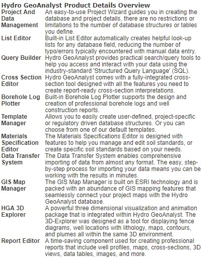
    With Hydro GeoAnalyst, you can expect the highest level of performance and a completely scalable solution to meet your groundwater project demands! Hydro GeoAnalyst is an all-in-one desktop concept that provides one-click access to many powerful features (e.g. Data Transfer System, Query Editor, GIS Map Manager, 2D Cross-Section Editor, 3D-Explorer, Template Manager, Report Editor, and much more!)
  • 價格

Hydro GeoAnalyst  水文軟體

With Hydro GeoAnalyst, you can expect the highest level of performance and a completely scalable solution to meet your groundwater project demands! Hydro GeoAnalyst is an all-in-one desktop concept that provides one-click access to many powerful features (e.g. Data Transfer System, Query Editor, GIS Map Manager, 2D Cross-Section Editor, 3D-Explorer, Template Manager, Report Editor, and much more!)

 Hydro GeoAnalyst Flexibility
  •   • Design the data structure, borehole log templates, and reporting styles that YOU want
  •   • Add or remove tables and fields, design an unlimited number of lookup tables and soil specifications, and export the modified database structure and templates for use in all your new projects
Hydro GeoAnalyst Scalability
  •   • Ability to expand the scope, size, and structure of your database at any point in the project, overcoming a major limitation found with other similar database solutions
  •   • Applicable for projects with data sets ranging from 4 to 4000 wells
Hydro GeoAnalyst Expandability

Hydro GeoAnalyst is now integrated with AquiferTest Pro and AquaChem so that you can start your projects in Hydro GeoAnalyst and expand your set of analytical tools as your projects grow to meet all of your hydrogeological analysis needs. 
 

WMS 水文軟體

Watershed Modeling System(WMS)是非常有名的流域模擬分析軟體,在全程支持流域(分水嶺)的水文地理學,水力學的圖形化建模,是美國地質調查局和環保局批准的環境模擬軟體。

WMS 水文軟體

RiverTools V4.0 地形和河流網絡分析

RiverTools 軟體是一個專業的地形和河流網域分析軟體,能快速從大數據量DEM中取出河流排泄區的網絡模型,對取出的河流網絡提供綜合分析,並以專業圖形方式顯示,實現地形模型可視化, 提供二次開發函數。可用在地貌和水利分析、洪水淹沒模擬、流域分析、防洪工程、災情分析、水文站水位流量分析、堤岸建設等應用領域。RiverTools強大的地形和流域分析功能為水利研究和應用工程提供了有力的支援。

RiverTools V4.0 地形和河流網絡分析

GMS 水文環境軟體

地下水資源和地下水污染模擬軟體。是美國地質調查局和環保局批准的環境模擬軟體。 GMS 是可利用的最複雜的和最包羅萬象的地下水模型軟體! 在美國政府機關,私人公司和超過90個國家以上的國際性組織,都已有用了成千上萬的用 戶在使用GMS,它已經被證明是十分有效的和令人興奮的模型系統。 GMS 每狀態地下水模擬提供包括位置描述,模型發展,口徑測定,後處理和可視化的工具。

GMS 水文環境軟體