

標題搜尋:
⭠ 左右滾動 ⭢

- PetraSim 地理介面軟體
-
類別地球科學軟體
-
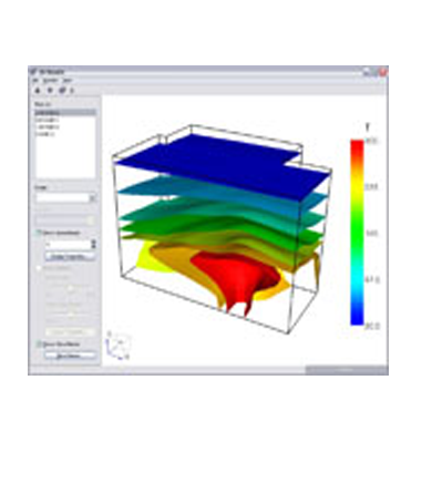
介紹PetraSim is the graphical interface for the TOUGH2 family of simulators. Developed at Lawrence Berkeley National Laboratory, TOUGH2 and its derivatives are recognized for their powerful simulation capabilities for fluid flow and heat transfer in porous and fractured media.
PetraSim 地理介面軟體
The TOUGH2 codes have been applied to problems ranging from Yucca mountain groundwater flow to multi-component environmental remediation. PetraSim makes the power of TOUGH2 accessible to modelers through an interactive 3D environment that includes mesh generation, parameter definition, and display of results. PetraSim significantly lowers the barriers to TOUGH2 use by freeing the analyst to focus on the model, while automatically handling the complex details of TOUGH2 input and output files. PetraSim includes TOUGH2, T2VOC, TMVOC, and TOUGHREACT executables.
GeoStudio 2D Flow 污染物擴散分析軟體
GeoStudio 2D Flow is a finite element software product that can be used to model the movement of contaminants through porous materials such as soil and rock. The comprehensive formulation of CTRAN/W makes it possible to analyze problems varying from simple particle tracking in response to the movement of water, to complex processes involving diffusion, dispersion, adsorption, radioactive decay and density dependencies. You can apply CTRAN/W to the analysis and design of geotechnical, civil, hydrogeological, and mining engineering projects.
Strater 鑽井探勘繪圖軟體
Strater offers the flexibility which excels at the time of the design and layout in the histogram. It is not so far with the user interface which operativity is high and is refined, can actualize design and data display with simple operation. Compilation in the histogram is simple. The histogram type which we would like to draw up is selected, the place of the page which arranges the histogram is clicked. And, the data file is selected, parameter is read. The histogram is completion now.
Voxler 地球科學3D軟體
Golden Software announces the release of Voxler, the NEW way to visualize your 3D data. It imports data from a plethora of sources, and creates stunning graphics that let you creatively visualize the cryptic relationships in your data set.